Thursday, April 24, 2014

Ripples


James Montgomery

             On the last day of our exploration into the Grand Staircase Escalante National Monument we ventured into a Hackberry Canyon, exploring millions of years of rock formations. While walking in and around the small creek that ran through the middle of canyon we noticed ripples in the water. Upon closer inspection we could see the soft sand ripples at the bottom of the stream migrating slowly forward with the current. Ripples begin to form through when the water disrupts the grains of the sand on the bottom of the body of water.  The steeper, down current side of the ripple is always at the angle of repose.
            Deeper in the canyon, we noticed a large boulder with lithified ripples dating back to the Jurassic Period.  These embossed ripples had been preserved over millions of years.
What a great example of uniformitariansim.  We could see modern ripples forming in a stream bed next to ripples formed in the Jurassic almost 200 million years ago.


Monday, April 21, 2014

The Kaibab Monocline


            During our Geology Field Studies trip to the Grand Staircase - Escalante National Monument the class camped within a structure called the Kaibab Monocline.   To the right is a cross section of the Kaibab Monocline as it looks near the North Rim of the Grand Canyon.   A monocline is a one-sided fold.  This particular one stretches north-south for about 240 km and dips steeply to the east  - up to 60o-70o.  This monocline was formed by subsurface movement on a fault during the Laramde Orogeny between 50 and 80 million years ago.  (Tindall, 2000).

Differential erosion of the tilted rock layers exposed along the monocline has created a series of east dipping ridges and valleys. Differential erosion occurs because less resistant rock layers like shale will wear away more quickly than more resistant rock layers like sandstone.   Here, the less resistant Tropic Shale and Carmel Formations weathered to form valleys, while the more resistant layers like the Navajo Sandstone and Dakota Sandstone formed ridges.  Stream erosion of the ridges creates the triangular hogbacks seen here.   Locally, this is called the Cockscomb. It was the down-warping on the east side of the monocline that allowed the young layers of the Wahweap and Kaipairowits to be protected from erosion.  Had it not been for the monocline, these layers and all the dinosaur bones they contain might have eroded away long before humans came around to discover them.

References

 Reches, Ze'ev. 1977  "Development of monoclines: Part I. Structure of the Palisades Creek branch of the East

Kaibab monocline, Grand Canyon, Arizona." Development of monoclines: Part I. Structure of the Palisades Creek branch of the East Kaibab monocline, Grand Canyon, Arizona. The Geological Society of America, 25 Web. 16 Apr. 2014.    <http://memoirs.gsapubs.org/content/151/235.abstract>.
Tindall, Sarah E. 2000 "The Cockscomb Segment of the East Kaibab Monocline: Taking the Structural Plunge." Geology of Utah's Parks and Monuments 28 pages 1-15.

Dinosaur Excavation

Before I went on our geological field studies trip, I thought that by some strange coincidence, paleontologists would just be walking along a random plot of dirt and find T. Rex skulls and bones poking out of the ground, kinda like this 60’s paleontologist guy below.

 How wrong I was! I had no idea how much work and effort a paleontologist puts into finding dinosaur fossils. I found the whole excavation process very fascinating, and so that’s what I will teach you about.
Before a paleontologist even begins digging, he has to survey the area he’s working in, and see if anything promising can be found. Fossils are found in sedimentary rock layers, and the layer we did our work in was the Wahweap Formation. A paleontologist surveys and prospects for fossils while hiking along the bases of hills and such. Fragments of fossils erode out of the ground and tumble downhill, so if any fragments are found at the base of a hill, you search up the hill to find more!
After identifying what has been found (if anything) and if it was actually a fossil, the paleontologist has to decide if it would be worth time and resources to pursue an attempt to excavate any fossils from the ground. On public land, permits must be obtained from the appropriate agency, such as the BLM or the Forest Service, before an excavation can begin. Once a permit is acquired, the paleontologist heads out with an excavation team and begins work. It involves a bunch of digging with shovels and picks until the bone layer is found.
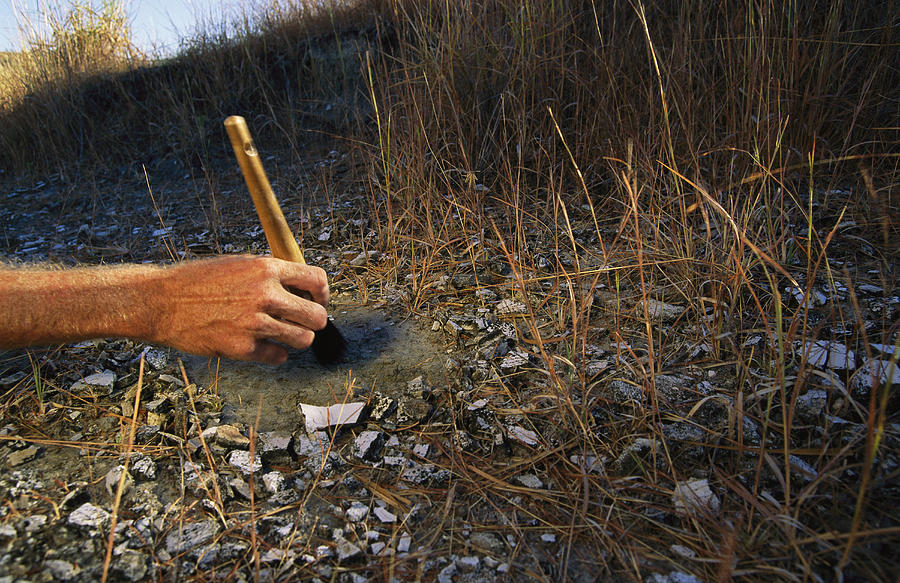
When the bone layer is found, the paleontologist will use only small hand tools and brushes to carefully isolate fossils.

Once the top of the fossil is exposed, hardener is put on the fossil, and then the fossil gets jacketed. The jacket involves lots of wet paper towels and strips of burlap soaked in a liberal amount of Plaster. The jacket sits until it is firm and solid. However, this is only the top of the jacket. Now the paleontologist digs under the fossil and layer of dirt and applies more jacketing material. When the bottom is solid enough to hold the jacket in place, the jacket is flipped over and brought out of the dig site to the lab. Pictured below is a large jacket being removed by an excavation team.

This is the process a paleontologist uses to excavate a fossil, and it’s totally not what most people think happens when fossils are found. I was glad I had the opportunity to go and learn about paleontology.


Wahweap Stratigraphy


           For my blog post I have chosen to write about the stratigraphy of the dig sites where we spent the majority of our time. The two main quarries that we worked in over our two days in the Grand Staircase Escalante National Monument were both located in the Wahweap Formation. The Wahweap Formation is approximately 80 million years old. The climate and geological processes that created it were perfect conditions for dinosaurs to live in and be buried.
            The Wahweap is composed of mainly two types of rocks: sandstone and mudstone. The plant and animal fossils found in these layers, such as petrified wood, Hadrosaur and Ceratopsian bones, indicate that there was a climate that could support both plant and animal life when it was being deposited. These sandstones and mudstones were deposited in swampy lowlands, shallow lakes, slow moving rivers and floodplains (http://www.gsenmschool.org/Geology/Unit_02/). Most of the running water flowing through the area, at the time, was runoff from the Sevier Mountains to the west, flowing toward the Cretaceous Interior Seaway to the east.  
As we look at the different sedimentary structures in the Wahweap, we can see more evidence of its environments of deposition such as fine grained sediment sizes and small scale cross beds which indicate slow moving streams and floodplains. The loose mudstone slopes of the Wahweap also indicate that there were lakes and swamps present.
            This lush and humid climate was perfect for dinosaurs. Erosion of the growing Sevier Mountains created a large source of sediment. The mountain building to the west created a trough in front of it called a foreland basin which allowed the large source of sediment to build up quickly creating perfect conditions for the burying and preserving of the plant and dinosaur fossils found there today.  


Siderite Concretions

At one of the quarries in the Wahweap Formation we were working on with Dr. Titus, the majority of the bones we were unearthing were rotten and past the point of being able to salvage. However, surrounding some of the rotten bone were rocks called siderite concretions. In the picture below you can see that this particular concretion was quite large and after we put it somewhat back together, you could tell that it was once encasing an 80 million year old hadrosaur bone -- the dark reddish color that you see is rotten bone still attached to it. According to Dr. Titus, these concretions often form around organic material and that’s why there was so much of it in this site.

10012729_616465285104738_2096722888_o.jpg

According to geology.com, concretions are formed by groundwater leaving minerals behind in soil or sediment. Many concretions form around a fossil like ours. Usually the cementing material is calcium carbonate. But, it is common to have iron carbonate (siderite) nodules like those seen here.

The concretions were part of the process that caused the bone in this location to be destroyed. Also, the siderite encased bone was not possible to extract. But at least the concretions saved enough bone to give us an estimate of the type and size of dinosaur that had been preserved there.


Wednesday, April 16, 2014

Digging Utah's Dinosaurs - Video: Digging It

Check out this video made by National Geographic in conjunction with their May 2014 issue.   They did a story about about the area that Snow College students also get a chance to work in:
Digging Utah's Dinosaurs - Video: Digging It